

This is the sixth of a seven-part series about a December 1982 trek across the Baja—enjoy! Will post the final Part 7 shortly. Part 1 is here. —Ken
Morning dawned gloriously with shards of sunshine lighting up the higher rock walls above. We continued up the canyon through narrows and more open areas, before negotiating a slightly difficult waterfall that invited brief use of the rope. Randall Henderson’s account of their March 1934 unsuccessful attempt on the mountain, also from the eastern slope, is contained in Desert Magazine, a publication he founded in 1937. He described conditions similar to what we found: slick rock, pools, falls, agave, manzanita. But the climbers were met with a serious rainstorm, falling as snow high above, and decided to retreat. He wrote:
Rubber on wet rocks is treacherous footing. Our feet were cold and our soggy [tennis] shoes began to disintegrate.
They returned a year later in perfect weather and reached a subsidiary summit late in the day, separated from the true summit by a chasm six-hundred feet deep. Again, they were forced to retreat. Two years later, in 1937, the third try was a success. Although the climbers ascended more directly from the desert, Henderson had this to say about the lovely canyon they viewed from above:
Diablo Canyon is a tremendous gash in the range … I’m sure Diablo has some gorgeous vistas for the photographer whose heart and legs are stout enough to pack his equipment up this great canyon.
The great gash passed under our boot soles and my bad ankle one slow mile at a time. With no camera and minimal down time to scribble any sketches for posterity, we’d just have to file away all this gorgeous scenery in our heads.
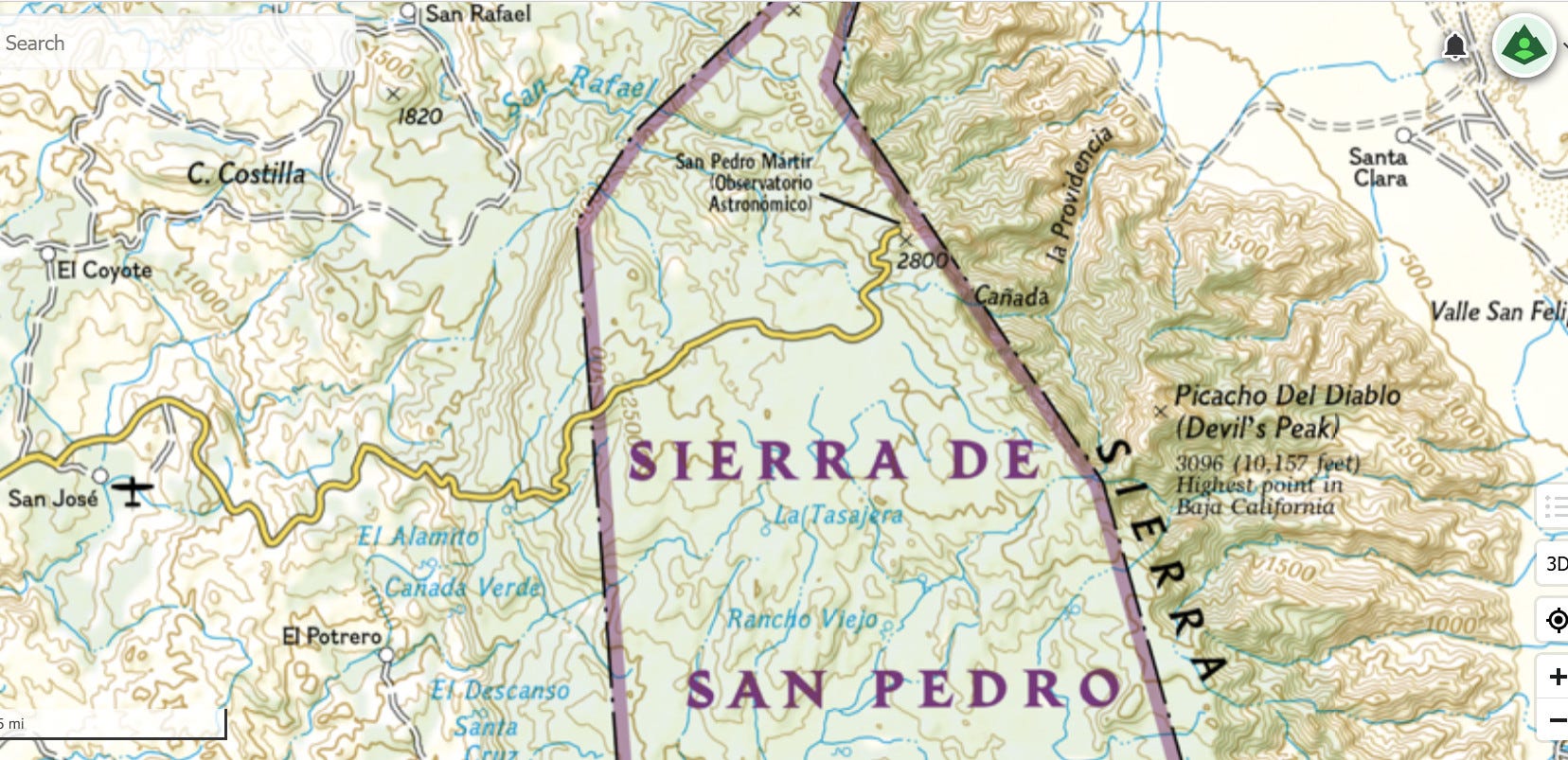
I pulled out the map to keep track of our position, based on the bends in the stream and the forms of larger gullies and buttresses. I noticed early on that our map was mislabeled, the canyons misnamed. Nevertheless, we were confident that we were scrambling up the correct canyon, not only because of the initial waterfall, but also the fact that it was indeed trending south to north.
The map called our canyon of the Devil something else, labeling the next canyon as Diablo. The names seemed to have shifted one canyon over, which introduced some doubt as to whether the higher peaks and other features were correctly labeled. But because Picacho del Diablo was the highest, we would have no trouble confirming whether we’d found the correct summit. Assuming fair weather, of course.
After lunch, the ground steepened again and by evening we guessed we were near an area known as Campo Noche. We probably skipped by the best campsite and ended up on a ledge under a large tree where we cooked up another pot of starch and goo that we heartily gulped down. I think Dennis noticed first that we were eating more than expected. We finished off all the pasta and wondered if we ought to ration what was left. With the hardest going still ahead, we were probably a good three days from civilization on the west side of the mountains.
The air cooled much more than during the previous night due to the substantial elevation we had gained over three days of rambling. Looking up the dark canyon walls, stars filled the gaping void above as noisy spoons scraped the bottoms of pots. Then a strange beam of light moved slowly across the easterly rim, as if a giant spotlight was being shone from the west.
The light faded after a minute or two and we invented various theories to explain it. Perhaps the fire boss near Rancho Santa Clara found out we were in the canyon and called on the Devil who went looking for us with his ghoulish flashlight from hell. Or maybe it was the observatory opening its doors with the lights on. But observatories are usually kept dark, and it was the absence of light pollution in the Sierra de San Pedro Mártir that had originally brought the observatory and a 2.1-meter telescope here in the 1970s.
I later theorized that a crescent moon, now approaching first quarter, may have been shining through a gap in the ridge, lighting up the far wall, not unlike the stone gaps in a Mayan temple where a solstice ray of sun among the shadows announces the arrival of winter. Oddly enough, the winter solstice occurred later that evening.
The night was cold so we began moving early the next morning to get the blood flowing. We passed a fork in the canyon above 6,000 feet, and the first snow. We were at the place where we would have to leave the canyon depths and begin heading up the steep, rock slopes and ledges of Picacho del Diablo. We strained to get a look at the route above, but the view upward was obstructed by trees and rock.
We could see much more snow on the mountain than we’d anticipated. Much ice had glazed over the shady places, which suggested there could be an abundance of it higher up. We had ice axes with us, but no crampons and only a short rope. I was concerned about my ankle and we debated whether to head up or not. We presumed we could manage the climb with the gear we had, but lacking crampons for our boots, the going could be slow and tenuous. The conditions would certainly become more challenging as we ascended, and we were still 4,000 feet below the summit.
We were young and strong and could probably manage an exposed, cold night up high. But this was not some corporate-sponsored expedition in which the two unwavering protagonists risk life and limb gathering film footage for the perverse joy of others. Rather, we were just two average climber-dudes scampering across the Baja on an extended Christmas vacation. Our trek with the Devil would not be followed by a news conference (we hoped), but by an appropriate sojourn on the beach.
The smart decision would be to head back down the canyon to the welcoming warmth of the Sonora. But we had come too far to give it all up, plus we'd already had our fill of lovely San Felipe. We compromised and decided to climb 9,600-foot Blue Bottle instead. We would descend from there to the national park, as planned, and continue west 20 miles more to another historic ranch, Rancho Meling.
Mildly disappointed, we kept to the right and climbed more steeply as the snow cover deepened. After another 2,000 feet of elevation gain, we found ourselves wallowing in deep powder, sometimes up to our thighs. The sunshine overhead had long since left us and temperatures dropped well below freezing, though we were in a beautiful place and trudged on.
Grinding upward in loose snow meant slow progress and we took turns breaking trail. We dearly wanted to get to the top and down the other side before dark. Not knowing the terrain or where we might pop out on the crest, we just kept climbing, reassuring ourselves that easier ground was not far above.
Not a minute too soon, the grade moderated and we could finally pick up the pace. Powered by the notion that the hardest part of the trek was nearly over, we quickly trudged through the last of the deep snow and reached the windy crest at sunset, probably around 9,500 feet. The presumed summit of Cerro Botella Azul, or Blue Bottle, was close by and we scurried upward to bag our hard-earned peak, just a few hundred feet lower than Picacho del Diablo.
To the west, a spectacular collusion of brilliant orange and red haze filled a third of the sky above the horizon. We could just make out the line of the Pacific Ocean. The moon above was hiding among scattered clouds.
To the east, the summit of Pichacho del Diablo glowed golden in the receding light and I sincerely regretted not bringing the camera. Bright orangey-pink slabs of granite ran at diagonals across the entire west face. Neither words nor pencils could adequately capture the moment.
With a bone-jarring wind blowing over the ridge and threatening to rip the threads from our jackets, we savored the visual feast almost without stopping and lunged over the crest.
We moved quickly downslope on firmer snow to gentler ground below, then rightward into the protective cover of coniferous forest. Once in the woods, in the last bit of twilight, exhausted, we called it a day. We stuffed down what we could muster from our dwindling food supply and stomped out hollows in the angled snow for our sleeping bags. We nevertheless had to curl around trees all night to keep from sliding down the slope.
As the fifth morning dawned since leaving San Felipe, we shook a centimeter of fresh snow off our sleeping bags, finished off whatever snack food was left, and cinched up our packs. It was easy going for a few hours. At one point we were gliding along the smooth, slick surface of a frozen creek as if on skates, yelping like teenagers. The creek drew us along with ease, but as it curved westward, we decided it would be safer to follow a northerly compass bearing to ensure we found the road between the national park and the observatory. That meant a modest climb up and over a ridge, which contradicted our innate sense of direction.
The calculation paid off. By nightfall, after countless miles of trailless hiking, we reached the snowy, trackless mountain road we’d been hoping for. Our headlamps shone along the silent white ribbon, and we agreed that if nobody else was going to the observatory at the start of winter, then neither were we.
We headed left, into the night.
Next up: Final Part 7—Done With the Devil, and a Ho-Ho-Ho!