

Below is the third batch of peaks from my 60 Summits quest in 2013, some of them quite special. You can find the previous batch here.
19. Witches Tower - August 18, 2013
At least a couple of my Summits of Sixty, I’ve pledged, must involve the use of a rope—and not for tying the beach chairs and beer cooler to the roof of the car. Yes, I’ve wanted to enjoy a couple of technical, though not too harrowing, treks (perhaps several?) this year involving passage over actual rock and/or ice, for the pure recreation of it.
In mid-August , as I made my way back to the Northwest for a week of fun, family and projects, my friend, Peter, of Bellingham, had already planned a five-day assault (nobody really assaults mountains) of Mount Challenger in the Picket Range with two of my old climbing buddies, Keith and Kiko. My timing was off by a day. Another friend was also busy with some other fun thing, so it was looking like I could be doing my climbing solo.
Alas, the weather forecast turned slightly wet and Challenger was sadly (for Peter) and happily (for me) postponed. But resourceful Peter still had a free weekend and an instant plan B that fit both my schedule and my mountain inspiration perfectly: an easy, two-pitch rock route up the backside of Witches Tower in the Enchantment Lakes basin near sunny Leavenworth. The hardest part would be getting there.
Because the Enchantments are gorgeous, they are popular and at risk of being loved to death, and for that, overnight visits require much advance planning for a chance at a permit. We, of course, had no permit. Our only legal option was to make a long day of it—a 14-mile roundtrip hike gaining and losing 5,400 feet. At 30, even 40, I’d've called it a piece o’ cake. At 50 and over, I'll call it, well, invigorating. It also entailed a four-hour drive from Bellingham.
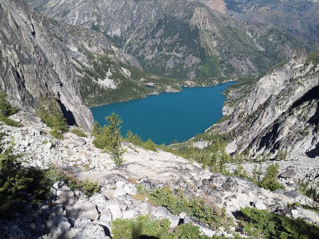
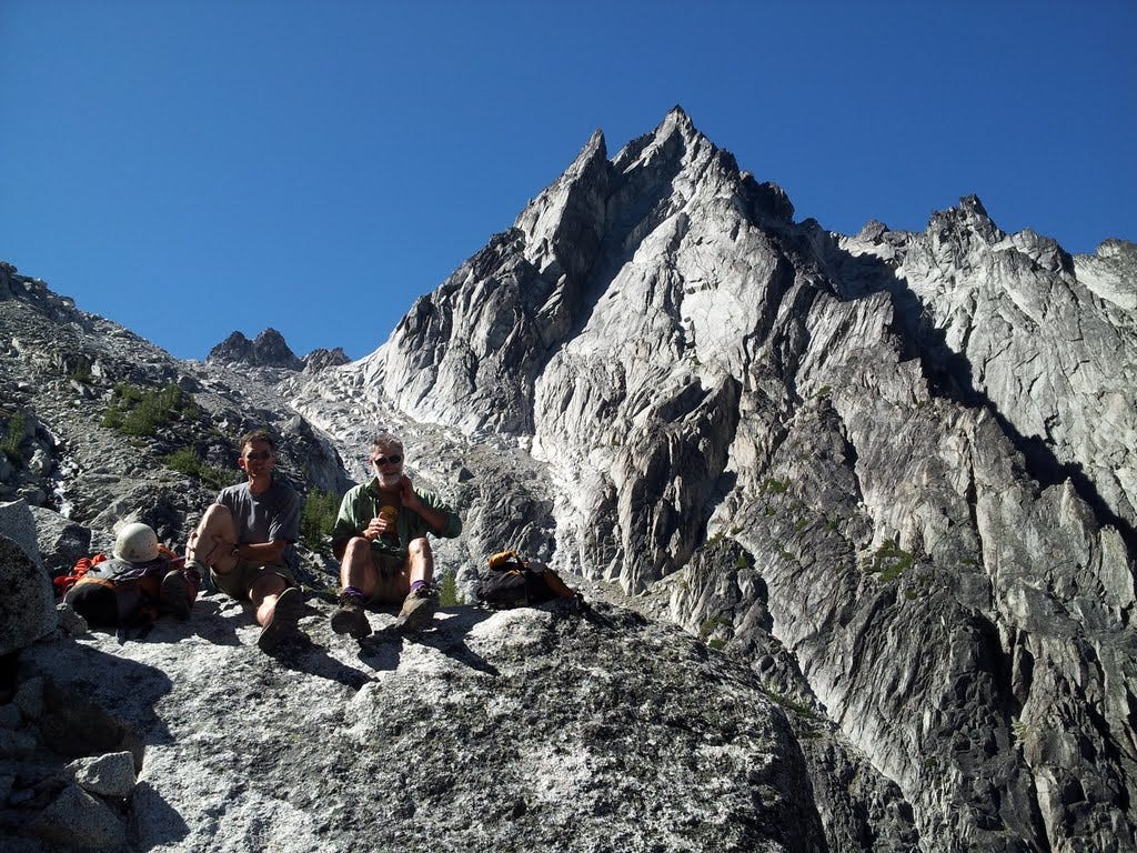
Peter, Kiko and I (Keith smartly opted out) left the burger joint in Leavenworth after dark on August 17 and drove up the Icicle Creek Road to the trailhead. A lumpy flat in the woods would have to do for an unofficial camp. After a lumpy sleep on sticks and roots, we broke away at dawn and had the first four miles and 2,000 feet of gain under our belts by eight-something a.m. We enjoyed a breakfast stop, so to speak, on the rocks at Colchuck Lake, well inside the Alpine Lakes Wilderness. Dragontail Peak, which I also hoped to summit that day, loomed majestically above. Witches Tower remained hidden behind it.
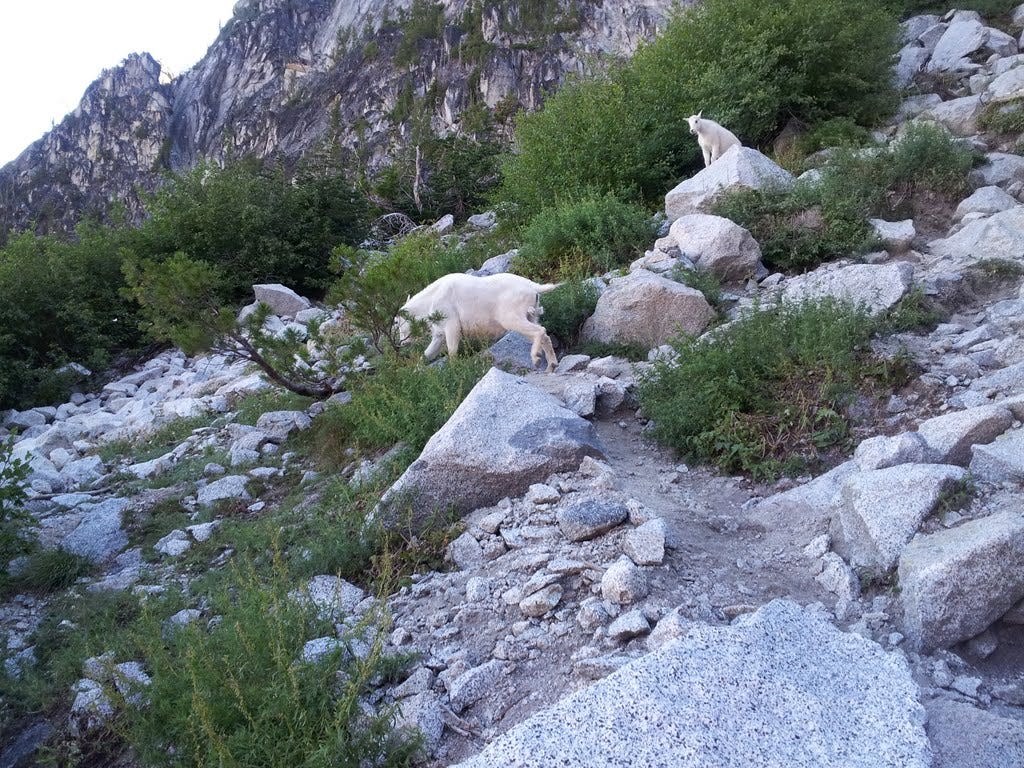
We rambled around the lake and over a boulder field to begin the steep, 2,200-foot infamous trudge to Aasgard Pass. It was a veritable goat trail. As I rounded a bushy bend in the steep and scrabbly path, a nanny and kid mountain goat stood ten yards ahead of me posing for a picture. Cool.
I took my time heading up from there so as to preserve some energy for the climb of the Tower and, of course, the equally lengthy return to the car that would follow. I was also a little worried about my left knee, this particular body part having ached on and off for months and only recently feeling semi-normal again.
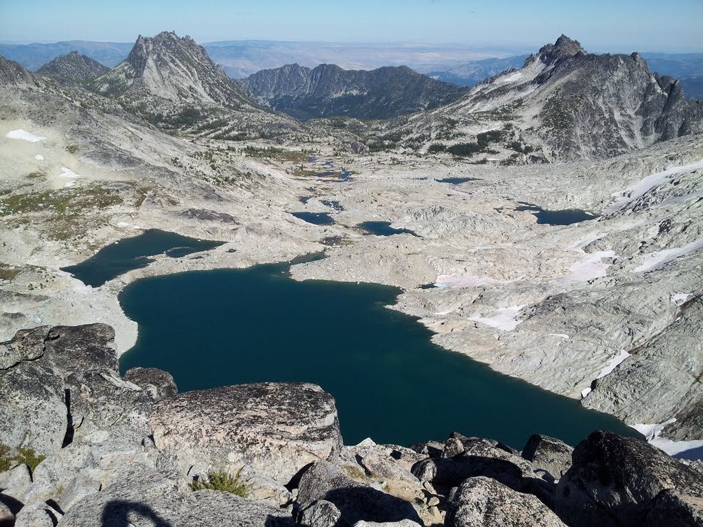
By 11:30 we reached the pass—and blue-sky views of the upper basin, the Tower, surrounding peaks and the pudgy dot of a lake now lying far below us. I shouldn’t be so descriptive. Most Cascade climbers would find all this to be a fairly straight-forward approach to a basic little rock climb. But compared to the Blue Ridge in Virginia, I felt chipper enough to be in the Alps.
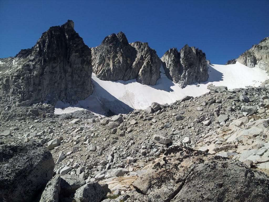
Beyond a tiny high lake, a steep, firm snowfield demanded ice axes, which we retrieved and stabbed into the slope with verve. We were soon at the col immediately behind our objective. We’d gained 5,000 feet over the course of the morning—a good test of my east coast legs. I felt great.
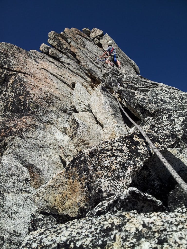
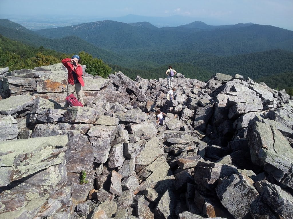
From here, Kiko scurried up a class 3 scramble route on the south face of Witches Tower, while Peter and I contemplated where to begin the roped route up the West Buttress. In no time at all, Kiko was hooting from above, waving his arms from the pointy-hat summit.
Peter and I differed on our preferred lines of attack (now who actually attacks mountains?), so as he further contemplated, I scrambled up the route Kiko followed and was soon waving down at Peter as well. Perhaps I was being unfair. Here, Peter is trying to make a serious climb out of this lovely rock pile, and Kiko and I are running up and down the peak like we’re playing King o’ the Hill. Kiko wanted no part of roping up, however, and after descending, headed off to Little Annapurna and his own explorations.
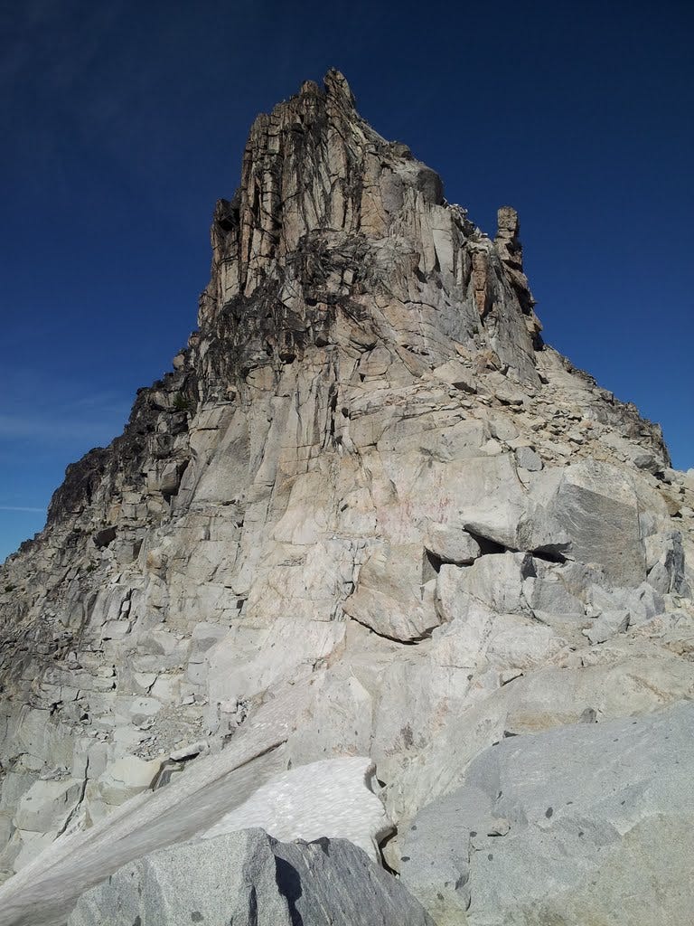
When I returned to the col, Peter had scoped out a more reasonable line of ascent and I quickly agreed to give it a go. He led it all, mostly class 4 with a short class 5 chimney, which was plenty for me, having not even donned a climbing harness or clipped into a spring-loaded cam for at least three summers. And just like that, we scooted up the granite, solid and broken into handholds and footholds in all the right places. I pushed through the chimney, around a corner and up a little friction face and there was the summit.
The views of the Enchantment Lakes basin was stupendous (there’s a word I’ve rarely used). Dragontail Peak was close by and the main ridge led south to the rounded top of Little Annapurna. We collected a few hero shots, enjoyed a rest and began the descent, which included a memorable little spot on a ledge where you get to step across absolute nothingness. It was an easy step, though it bumped up my pulse a couple of beats.
Given the long upward grind from the car, the extra scramble up the summit, and the fact that it was now 5 p.m., I knew Dragontail was out of the running and, mildly disappointed, I let it go. The Witches Tower was enough success for one day and now I needed to get down. The left knee had finally come around and was beginning to complain a little about the extent of the day’s adventure.
Peter raced off to Little Annie, since he had not yet do-si-doed up that easy summit (I’d been up there several times). While he dashed southward, I managed a controlled slide down the hard snow using my ice axe as a rudder and brake. I skittered back to the pass and worked my way down the rubble trail at a careful pace. I made decent time, but knew that Peter (a veritable billy goat himself) would eventually catch me—and that he did at the exact spot I’d stashed a few cold beers at a tiny creek crossing that morning.
Kiko, after summiting Little Annapurna, opted to hike out the long way, a chance to trek through more miles of high-end scenery, essentially the entire basin. He would exit via the Snow Lakes Trail. We would pick him up later on our way back to Leavenworth.
By the time Peter and I finished our beers, it was dark enough for headlamps and we stumbled the final few miles to the car. He spotted a rubber boa along the way, an intriguing, harmless and rarely seen green snake the size of a typical garter snake, and we watched it writhe in his hand awhile. The knee by then was not happy and the last two miles did not register well on the fun-o-meter.
The parking lot finally emerged from the darkness and we were soon depacked and debooted and on our way to find Kiko. We reached him a bit after 10 p.m. He’d been lying on a picnic table debating whether to call for search and rescue. He’d left us in a potentially precarious place with no assurance of our safety. It was nice that he was concerned.
Peter had to work the next morning, which meant four hours of driving before we could fully relax after an ambitious day. Kiko and I let Peter sleep in the back seat of his Prius and traded off steering duty on the endless drive home. By 2:30 a.m. we were back in Bellingham, exhausted campers, but happy ones nonetheless. For me, it was nineteen down and 41 to go.
20. Cold Mountain - September 1, 2013
Our Labor Day getaway for 2013 was back to the Blue Ridge, this time down south a bit to Cold Mountain south of Charlottesville for Day One, and up to Shenandoah for Day Two. Cold Mountain is reportedly one of the more scenic hikes in Virginia. It promised an easy summit that seemed reasonably baggable despite my ailing, but recovering left knee, and despite scattered thunderstorms in the forecast. Kris and I grabbed a bagel and coffee over on Wisconsin Ave and hit the highway. We were at the trailhead around 1:00 pm (Sept 1).
Clouds threatened, so I suggested we reverse the planned 6-mile loop so that we would hit the summit early in case the sky unloaded on us. We followed the AT gently upward in forest and soon entered the first of several grassy meadows, the second being very large with expansive views.
Minutes later and before we’d left this meadow, the rain started and thunder began to boom from a couple ridges over. It looked like we were only catching the edge of it, so after a brief wait under a tree, we got a break and went for the top, not even an hour from the car. The third big opening held the summit rock, appropriately festooned with an old USGS marker. We snapped photos as the rain began again and the clouds grew more ominous.
Descending the trail along a ridge, we regained the forest, where we hunkered down awhile in the moderately rainy rainstorm waiting for it to pass. We weren’t too disappointed that the lightning strikes kept their distance. When the next break came, we continued our descent to an outcrop that offered a good lunch spot. The sun reappeared right on schedule and we were soon steaming ourselves dry again while gobbling cheese sandwiches.
The improving weather suggested we skip the loop hike altogether and retrace our steps so that we could savor the views on top that we had to skip through while being pelted by rain. So we ambled back, slow and savory, finally reaching the car around 5:00pm.
We headed up the Blue Ridge Parkway close by, and a couple hours later—after sighting our second black bear out east (crossing the road in front of us)—we rolled into the Loft Mountain Campground in Shenandoah, just before dark. Lucky us, there were plenty of holiday campsites remaining, probably due to the rain.
21. Blackrock Summit - September 2, 2013
We picked up our camp at Shenandoah's Loft Mountain on Labor Day, and not missing a beat, headed for the camp store for some morning joe. A ranger was leading a talk-and-walk a few miles away to Blackrock Summit, which sounded like a mountain top to me. We scooted over to the trailhead to get our minds prepared for another itty-bitty mountain climb. Yeah, pretty easy, but still nursing a sore knee, I’ll take what I can get.
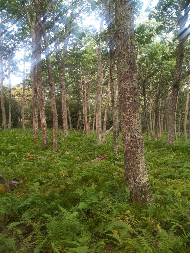
The ranger pointed out a prescribed fire area, where the Park Service had intentionally burned the forest on one side of the trail in 2008 to mimic the ecological benefits of natural fire. He stopped again to show us a small American chestnut tree. All but extinct, these once wide-ranging, giant, nut-producing trees were dominant in Shenandoah and across much of the Appalachians. Tree trunks up to ten feet across were not uncommon. Instead of looking out at a sea of oaks, hickory, locust and other trees we’re more familiar with today, Americans over a century ago were marveling at great stands of giant trees rivaling even the large, old-growth conifers of the Pacific Northwest. As in the NW, the big trees were also decimated by logging throughout much of their range.
When Asian chestnuts were introduced, they brought a disease, chestnut blight, to which the American trees had no natural resistance. They died off by the millions, decade by decade, until nearly all disappeared. The roots often remain alive underground and frequently send up new shoots, but the blight sets in after a few years and the young trees quickly die off.
Genetic monkeying has produced trees that are 94 percent native and six percent Asian, which apparently provides for some resistance to the blight, but the Park Service has been reluctant to plant the genetically modified trees at Shenandoah in order to preserve natural forest conditions. It’s very hard to imagine what the forest would have looked like with these behemoths peppering the landscape.
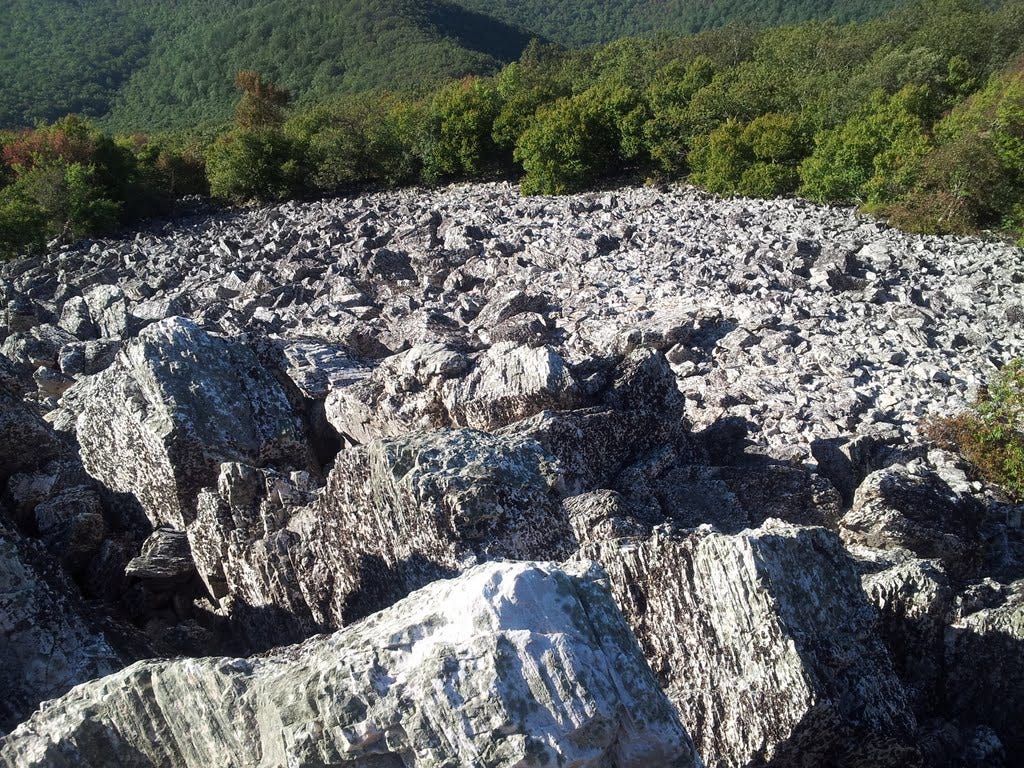
The ranger led us up to the summit area, a large rock pile created by freeze-thaw cycles cycling endlessly. A large talus field extended across the upper slopes and a good distance below the trail. The ranger warned of rattlesnakes that lived in the rocks. Unfazed, a mom and two young rock scramblers, aged 5 and 6, headed for the summit, with Kris and I struggling to keep up. All enjoyed the clambering and no one saw a snake. The view was most excellent.
We returned to the car, headed north on Skyline Drive for the next little summit, and sure enough, spotted a rattlesnake slithering across the road in front of us—our first sighting of the timber rattler I’d been looking forward to running into for the past two years. It was a-okay by me seeing this one on the road instead of in the rockpile. S/he moved somewhat awkwardly, a snake with a limp, I figured, and we wondered if it had been injured by a passing car. It seemed to strain to reach the grassy shoulder then laid there awhile keeping still with its head up. I dared not to move in too close for a portrait.
22. Hogsback Mountain - September 2, 2013
This little wooded bump hardly gets a mention. I’d mistaken it for something else I thought would make a nice easy walk-up. The top is all radio towers and buildings and no views, an anticlimactic way to end a fun couple of days. But we were there and it’s September already, so darn tootin’ I’ll take credit here for summit number 22. There were a few nice spots along the way, so it wasn’t a total loss, plus we got to add a praying mantis to our East Coast wildlife sightings list. The mini-trek also put me over the 100-mile mark to date in attaining my sixty summits. But good grief, it’s September already and I’ve got 38 to go. Hmmm.
23. Maryland Heights - September 8, 2013
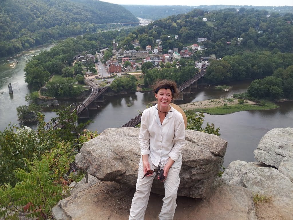
We braved a “sunny and 80s” forecast with our third trip to Harpers Ferry, this time to hike up the popular trail to Maryland Heights. The town of Harpers Ferry dates from the 1790s and has a very rich history (Civil War and pre-Civil War) in an exceptionally scenic setting where the Shenandoah River spills into the Potomac. An old railroad bridge over the latter (now part of the Appalachian Trail) and high cliffs above offer dramatic views and it was time we got us some. We rolled into town mid-morning and rambled a bit before heading across the bridge, briefly along the C&O Canal, and up the steep trail to the Heights.
The trail climbs steadily, passing historic gun placements where cannons up to 5 tons were hauled up the mountain by Union soldiers to defend the area from incursions by the South. The biggest guns could lob a 100-pound slug more than two miles. But after being turned away once, the Confederates succeeded in routing the Yanks and many were killed, with thousands taken captive.
There is too much history to pretend to summarize here, but Harpers Ferry was very much in the thick of it, essentially located on the line between the North and South. Plus, there’s the great story of John Brown who, shortly before the war, was determined to end slavery with a rag-tag mini-infantry under the cover of darkness, if only he could. I highly recommend the recent book, Midnight Rising, by Tony Horwitz, as not only a gripping biography of Mr. Brown, but a wonderful lead-up to the inevitability of a Civil War.
A spur path led us down to the overlook atop the cliff with the million-dollar view of Harpers Ferry. From there, it was another steady gain to the ridge top and easier ground leading to the remains of a stone fort and the gentle summit of Maryland Heights. Three states, interestingly, converge near Harpers Ferry. We’d left DC in the morning, drove through Virginia, landed in West Virginia and hiked sweatily into Maryland.
On the return, the river demanded we stop and soak our feet a spell. Next time, we’ll remember the sandals since the river is quite wadable, though the gravel bottom is tough to walk on with dainty feet like mine. However, large flat rocks do lay just yards off the bank, passing time till some lazy hikers come out to sit on them. Flocks of tubes and rafts also drifted by. That’s a kind of lazy we’re going to have to get penciled in on the calendar before these 80-degree, late-summer days are all used up.
24. Furnace Mountain - September 14, 2013
A sunny summer Saturday in September (14th) I sauntered off to Shenandoah for a couple of summit hikes near the south end of the park. Despite the longish drive, it was a fine outing and a chance to knock off a summit I’d missed out on in April 2011 (Furnace Mountain). Plus, the easy jaunt up Turk Mountain would end with one of the nicer summit views in the park.
I planned my drive down the west side of the range where I could pick up the Furnace trail at the same trailhead I visited with the Wanderbirds during that 2011 hike up nearby Austin Mountain. The trail climbed comfortably in pretty forest and bright morning light.
Not far up the path, I passed the biggest pile of bear scat I’ve seen out east, still fresh and rife with berries. Having borrowed Kris’s trekking poles due to my bum knee, I rapped them on the rocks occasionally to warn my ursine friend that I was heading up for a visit. But the bear never showed him/herself, so I continued on to the little rock outcrop near the summit for some minor munching and a view across Madison Run to Austin Mountain before retracing my steps to the car.
25. Turk Mountain - September 14, 2013
From Furnace Mountain, I drove south to Waynesboro, thence eastward to the southern park entrance at Rockfish Gap and north a few miles to the Turk Mountain trailhead. The hike briefly followed the AT, then broke right to descend 100 feet or so, before regaining that and another 300 feet to the giant talus pile at the top. The ledges and tumbled boulders offered plenty of great spots to laze and enjoy the excellent view.
26. Sharp Top Mountain - September, 2013
The trail begins at an attractive squared-timber building occupied by a camp store and ascends forest and many stone steps to the rocky summit area 1.5 miles above. Much of the finish is up more stone stairs leading to a high patio and 360-degree views. An old stone “cottage” is nestled in the rocks immediately below, somewhat out of place, but historic and unique nonetheless. We lounged a bit, but once on our feet again we hiked a short loop around the summit area, then headed down to a spur that led over to Buzzards Roost for one last view before calling it a day and motating northward.
27. McAfee Knob - October 4, 2013
On October 4, I left DC early for the long drive to southwestern Virginia and beyond for my long-awaited three-day adventure to the fabulous Blue Ridge country between Roanoke, VA and Asheville, NC. Originally, I’d planned to visit Great Smokies National Park, which would be pushing it for a long weekend foray, but thanks to a government shutdown and closure of the parks, that option went out the window. Fortunately, there were plenty of tantalizing alternatives and I was feeling perfectly giddy about seeing some new country. My knee felt almost normal again and the weather forecast was summer-perfect. Yippee!
The first stop was just north of Roanoke, McAfee Knob, rated as one of the best summit hikes in Virginia. It is also a well known stop along the A.T., which nearly passes over the summit. With the national parks being shut down, I presumed I’d have plenty of company on the trail. Instead, I nearly had the place to myself. It helped that it was Friday.
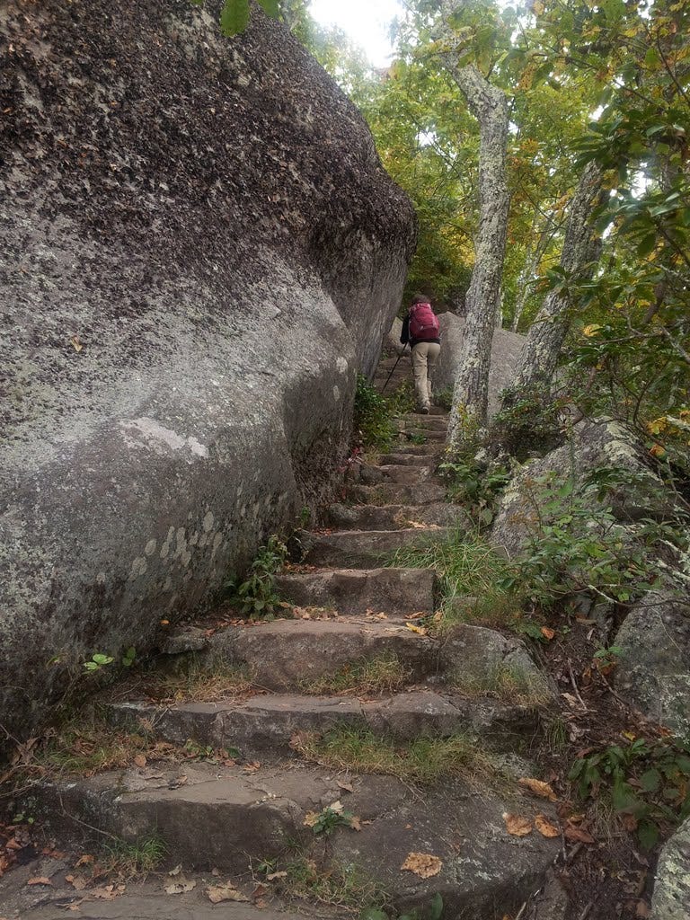
I pretended not to see the “area closed” sign stapled to the trailhead marker at Catawba Summit. I’d read online somewhere that the rangers would not likely be booting people off the AT, even those sections managed by the National Park Service. I marched on. The four-mile trek to the knob was scenic and enjoyable, passing a camp shelter, a briefly annoying powerline corridor, and some giant boulders in the woods, while gaining about 1,700 feet along the way.
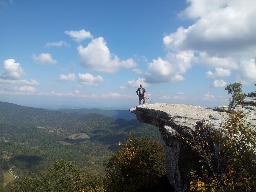
At the summit, one is greeted by an impressive slab of overhanging rock and a perfect view of the Catawba Valley and long ridges of still-green forest extending out to the horizon. A young woman offered to snap a hero shot for me and suggested I sit on the edge of the ledge for a really cool picture. I politely declined. I found a shady spot, devoured a bagel and soaked up the scenery for an hour before finally heading back down. Summit 27 was in the proverbial bag.
Find the next batch of 2013 summits here.