This is the seventh and final batch of my 60 Summits adventuring in 2013-14. You can find the previous batch here. If you missed the earlier write-ups, you can read the first batch here, then click through to view the rest. And if you made it this far, I’ll just say Wow! That’s quite a feat in itself.
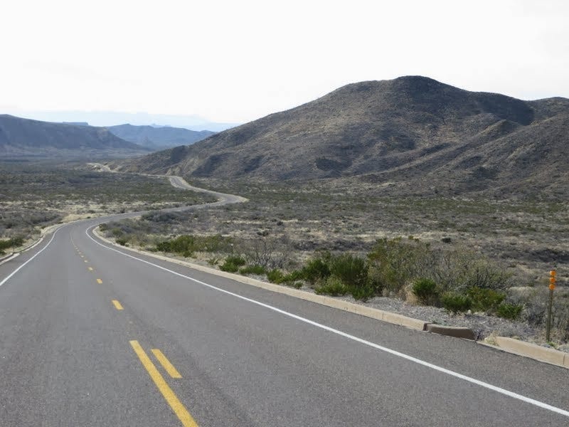
Big Bend National Park
By mid-January I’d gained 50 summits in my quest for Sixty, but with only two weeks to go, how was I ever going to manage ten more? I started scanning the map of the good ol’ U.S. of A. for sunny winter destinations with affordable airfare. My pointer finger soon landed on Big Bend National Park in west Texas. It should be sunny and 60s in January, I learned. That was all I needed to know.
On the one hand it seemed a bit frivolous to jet over to Texas for a few days of hiking. But on the other hand, I was on a mission and hadn’t been on such an adventure in a beauteous new place for way too long. Most of my vacation time seems generally consumed by domestic duties and the like, with a day or two of fun tossed in here and there for sanity’s sake. Kris was also traveling to Seattle for a 10-day winter break with family, so I figured I could tack on a couple of vacation days to a three-day M.L. King weekend and flew to San Antonio on January 16.
After a long drive west from San Antonio—and a near accidental detour into Mexico after missing a turn—I arrived at the Chisos Basin campground just after dark. For the next four days, it would be total Blissville, with five new summits added to the count. I had to consult my rule book a few times to be sure a couple of them would qualify. But since I write the rules, I figured the chances were pretty good.
51. Casa Grande (TX) - January 17, 2014
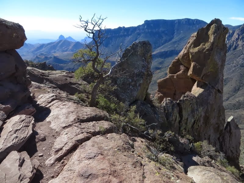
I crawled out of my frosty tent early dawn for my first good look at the Chisos Mountains, having arrived under stars the night before. The mountains surround Chisos Basin like a giant caldron, and in fact, the place owes its existence to several large volcanic eruptions 30 to 60 million years ago, plus some artful erosion in the years since.
Imposing Casa Grande rose high above and grew more impressive with the advancing morning light. It is thought to be a remnant lava cap that flowed over more erodible ash and sandstone. At the time, I wasn’t even sure yet what mountain I was looking at, given the sparse research I’d done beforehand. But after a morning stroll to the ranger station up the hill and a look at the map, I learned its name—and also discovered that there was a steep, unofficial trail to the summit. After some book browsing and putzing around, I was finally on my way.
The climbers’ path leads west from a mile up the Lost Mine Trail. A jolly jaunt led along the easy ridge, then the grade steepened as I clambered up light brush, rocks and scree to the first false summit. The trail faded through a gentle saddle then reappeared for the climb past rock towers to the next false summit, where a natural arch added an extra flair. After slogging over the crest, I was a little surprised how distant the summit still appeared. I kept on, feeling a little lonelier as I climbed far above the surrounding desert.
Despite a perfect, 70-degree day, I saw no one else on the route. I began to wonder about the super-abundance of warning signs throughout the basin and at trailheads going on about the risk of mountain lion encounters, since they are frequently spotted in the Chisos. But they only hunt early and late in the day, right? Black bears too. I marched on.
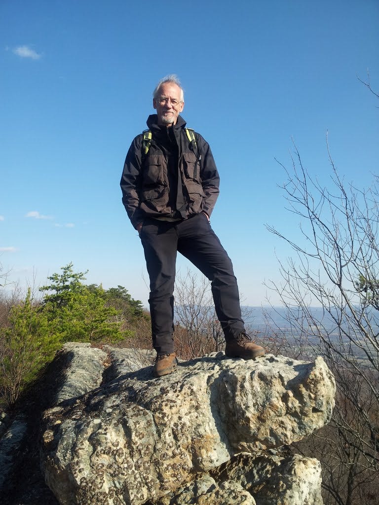
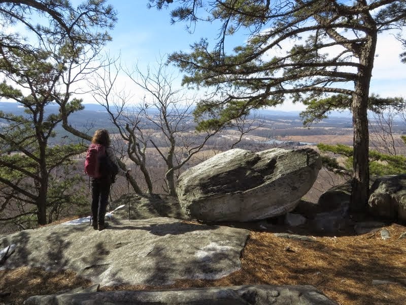
Another very steep and skinny scree slope finally brought me to the top where I wandered among two gentle high points to be sure I’d nabbed the correct one. The view was tremendous and I enjoyed a 2:30 lunch gazing down on my tent from my 7,325-foot perch. I’d gained 1,600 feet over a 4.2-mile round-trip hike. Not a bad way to get acquainted with a fabulous place that had somehow evaded my radar for so many years.
52. Emory Peak (TX) - January 18, 2014
Another cold night and brilliant moon was followed by a perfectly sunny day that warmed half way into morning. I’d decided to head out early to make the 12.6-mile loop out to the South Rim, one of the park’s classic hikes. I would also add the 3.2-mile side trip up Emory Peak, the highest in the park, plus some minor off-trail wandering to total 16 miles and about 3,200 feet of elevation gain.
I hiked in via Pinnacles and Boot Canyon Trails and returned via the Laguna Meadow Trail. Half way up to the saddle, I passed a heavyset fellow who looked much younger than I and who seemed to be huffing more than he was puffing. I bid him well, quietly hoping his heart would hold out long enough to enjoy the promised views ahead.
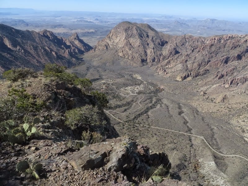
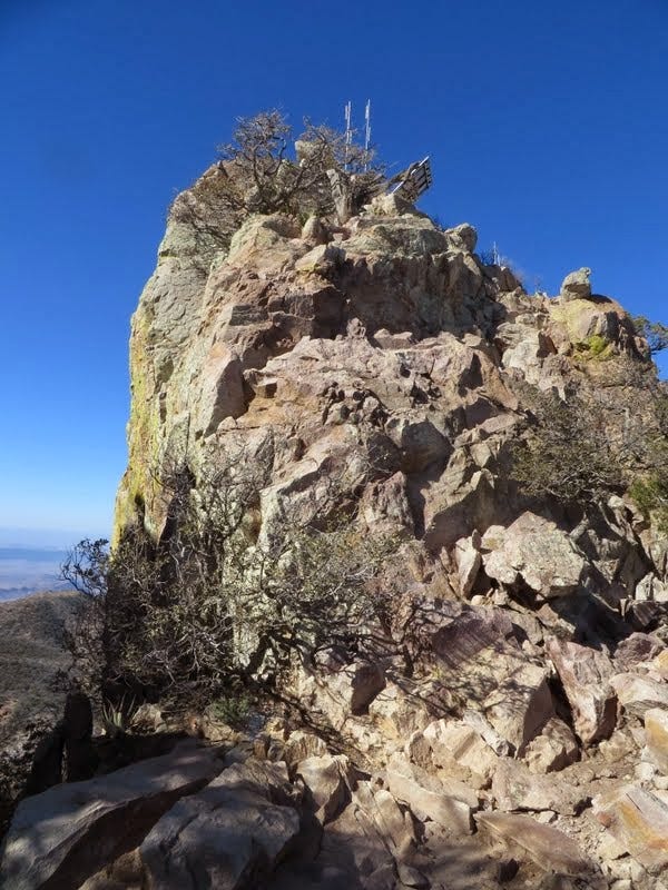
The first half of the loop is a splendid trek through gorgeous terrain past a large rock tower shaped like a cowboy boot (it had to be in Texas) to a million dollar view of Mexico from the rim. I could have sat and stared for hours. The sidetrip to Emory was also exceptional. The exposed summit rocks were exciting enough (class 2-3) and well worth the extra push, even if a radio transmitter and solar PV panel kinda mucked things up at the apex.
On the way down from the peak, I passed my hefty friend, still truckin’ and aiming for the summit. He confided with a smile that “Climbing Emory was probably the last thing a 320-pound man should doing on his vacation.” As far as I know, he made it too, since he was getting pretty darned close at that point. I made a good trek myself that day, but I think I was outdone by the big guy.
53. South Rim High Points (TX) - January 18, 2014
After enjoying a sandwich and the views on the South Rim awhile, I figured I should get moving. I still had a good seven miles of walking to do. I wandered over to a high point toward the south end of the rim, then approached another point on the way back toward Emory. I made a short off-trail hike in light brush, partly along an intermittent boot trail to the gentle summit (Point 7395)—hardly a noteworthy accomplishment, although it was just far enough off the trail to get that lonely feeling again in mountain lion country. I tagged the summit and snapped a photo of Emory rising between the trees.

As I headed down, I immediately lost the boot track and became briefly disoriented. However, I knew that as long as I moved eastward, I’d soon stumble on the trail, which I did after a short argument with some brush. I determined that two easy off-trail high points added up to one countable summit so I granted myself a second peak for the day. Seven to go.
The scenic hike back to Chisos Basin passed below sunlit Emory and offered many more great views of the park. The miles slipped by like butter and I was back at my cozy tent well before dark.
54. “Croton Mountain” - January 19, 2014
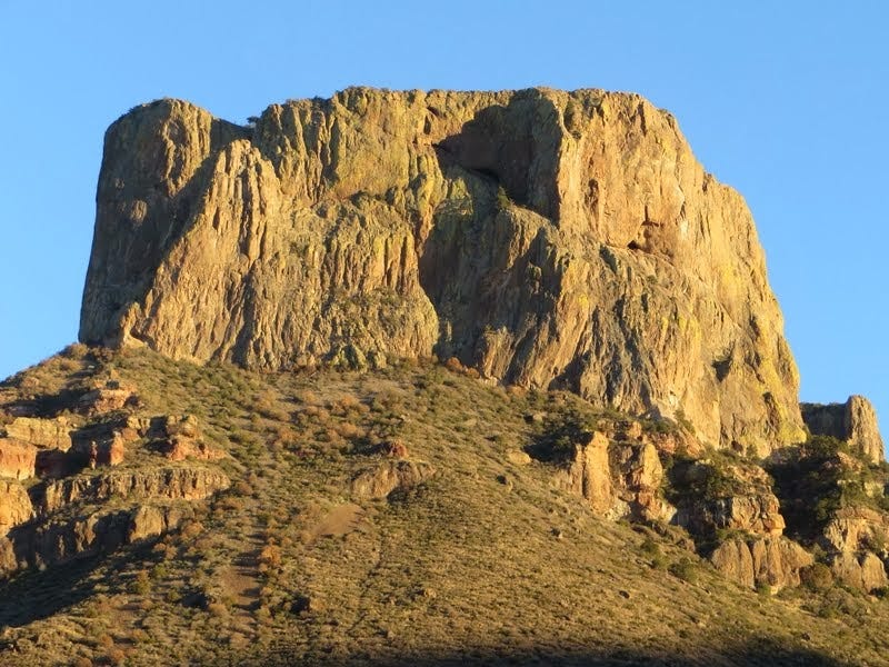
Day Three at Big Bend was to be a mellow one, a semi-rest day, though I hoped to still get up an easy summit somewhere. I’d set my sights on Cerro Castellan, a dramatic steep-walled peak visible from great distances across the desert. My research suggested there was a steep but doable scramble route up the east face, maybe 2-3 hours round trip.
When I got there, it looked harder than I’d imagined and I let it go, fearful of breaking an ankle or bonking my bean or some other body part that might leave me stranded with no likely rescue. In hindsight, I now wish I’d given it a go and simply turned back if the going got tough. But I’d already burned up much of the day traipsing around the desert, visiting the narrows at Santa Elena and Tuff Canyons. If I was to bag a summit, there would be no time left for an alternate if Cerro Castellan didn’t go. So I moved on. What a wuss.
Cruising north along the Ross Maxwell Scenic Drive, I spied several small mesa-hills that I thought might do the trick, but most seemed either too small and dainty to count or too big and hulky to ascend in the time allotted. I finally landed at a little mountain next to Croton Spring, an easy walkup to be sure. I clambered up its 400-foot-high eminence, which was like climbing a giant heap of loose bricks and baseballs (it was volcanic). I waved my imaginary sword at the top, decreeing Croton Mountain as my 54th summit. Well, okay, it was only a mile round trip, but I’m counting it!
I celebrated a couple hours later by ordering up a burger and brew at the Chisos lodge restaurant/bar, and watching my Seattle Seahawks eke out a victory in the championship game against San Francisco. (It was a banner year for the ‘Hawks. Two weeks later, they would go on to trounce the Broncos in our first and only Superbowl victory—and on my birthday, no less!)
55. Lost Mine Ridge (TX) - January 20, 2014
Day Four was my last at Big Bend, since my mini-vacation was nearly over and I had a plane to catch in San Antonio the next morning. I also had six hours’ worth of driving to do just to get to the airport. However, I calculated I could hike up the Lost Mine Trail, another park favorite, in the morning, and either stand on the high point of the ridge or possibly wander a half-mile over to a higher high point that would earn me at least one extra brownie point.
Lost Mine Peak itself, was a much more challenging and committing hike with a 4th class finish to the summit. It was appealing enough, but better saved (and safer) for a party of two or more. I enjoyed a breakfast buffet at the lodge, packed up the tent and headed to the trailhead.
I’d already been up the first mile of trail on Day One (for Casa Grande), so except for slowing down to ogle a few deer on the way up, I made good time reaching the saddle and chugged on. The ridge crest seemed like easy work, so perhaps the steady diet of daily hiking was already giving me some new strength.
At the crest, I realized the sub-peak I’d noticed on the map required somewhat of a brush bash to get to. It did not look highly appetizing. Lost Mine Peak looked very appetizing, but no chance now of that happening.
I also noticed a cool-looking summit rock at the end of the official trail, so that would have to suffice. To make it more official, I carefully scooted up onto it, and stared down a substantial distance at the trees below my boots. I think the couple nearby were wondering the same thing I often wonder when I see someone getting a little too close to the edge. What is that crazy guy doing up there? On the way back I tagged another pile of rocks just in case it was higher than the first, though that didn’t seem to be the case. The tally: 4.8 miles and a gain of 1,100 feet.
I’d bagged five summits in four days, had a heck of a good time in a new-to-me national park, and enjoyed a brief hit of summery weather in January. As it turned out, my flight to DC the next day was cancelled due to a major snowstorm. But the delay was manageable and the next plane made it through. It was my first time actually landing in a snow storm. And just like magic, I was back in the frigid confines of a cold, cold winter on the Mid-Atlantic Coast.
56. Minor’s Hill (VA) -
This one was a peak of baby steps, 10.5 miles worth, from our front step in Glover Park to the highest hill in Arlington, Virginia—rising 459 magnificent feet above sea level. Because of the snow and the cold and the fact that I still needed five summits to complete my Sixty with only a week left to accomplish the feat, I was getting desperate. So by my reasoning, if I walked ten miles to get up a hill, then that darn hill counts. And I won’t have to drive anywhere to do it.
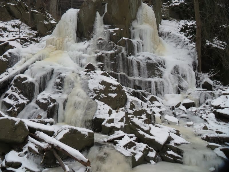
On January 25th, I walked our the front door, down through Georgetown, out along three pleasant miles of the Potomac Heritage Trail past frozen waterfalls, then west up Donaldson Run and into the burbs for my final assault on the Minor massif.
It turns out that Minor’s is an interesting hill in history. The Minor family settled it, one of whom was friends with President James Madison. Madison briefly took refuge there in 1814 when British forces set fire to the White House and Capitol during the War of 1812. He was our fourth president, the father (i.e., major wordsmith) of the Constitution and Bill of Rights, and hubby of Dolley.
The Hill was later occupied variously by both Union and Confederate troops jostling for territory during the Civil War. Today, the old stories are mostly buried beneath asphalt streets and a suburban neighborhood. I walked up to the highest bit of dirt I could find and snapped a photo just to be weird. The East Falls Church Metro station is only a mile or so down the hill, which made for an easy return home.
57. Little Schloss (VA) - January 26, 2014
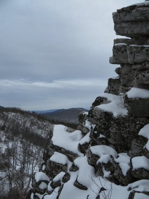
Despite a week of snow on the ground in DC, not a lot had accumulated and I guessed that six inches or so might be blanketing the nearest clines of the Blue Ridge. A short hike with 1,200 feet of gain had caught my eye weeks ago, so off I went to give “Little Schloss” a try. The main roads were generally dry, but the last couple of miles into the George Washington National Forest were packed snow, with enough in the center to make me worry about dragging bottom in Kris’s car. I parked about ¾ mile below the trailhead and walked the rest.
A single line of day-old boot tracks led up the snowy trail, with dog tracks crisscrossing excitedly every 50 yards or so. The tracks only went upward, so I wondered if this hiker might have done the longer loop option that I was not planning to do. After all, I was in peak-bagging mode at this point and didn’t need no more stinkin’ miles than necessary.
Actually, it was a lovely hike and I was at the ridge in no time, looking up at the steep scramble to the summit. The snow-covered talus was no problem at all and I quickly ascended for the splendiferous view above, two miles from the car. The descent was uneventful and I was back home in plenty of time for a jambalaya dinner party with Kris’s boss and their extended family of friends.
58. Bull Run Mountain (VA) - January 31, 2014
I only recently discovered that the trails at the Bull Run Mountains Conservancy, an hour west of DC, happen to include a hike up a ridge to a high point with a view. Perfect! I had two days to go and three summits to scale to avoid a midnight self-pumpkinization on February 1st. So, Kris and I headed out on January 31st, a sunny and almost spring-like winter day, for summit #58.
We parked at the Mountain House and rambled along the Fern Hollow Trail past the striking remains of an old grist mill, ice well and family cemetery. The creek below us, Broad Run, was flowing, but largely capped in thick ice from an unusually cold January. We soon met the Chestnut Ridge Trail and followed that to the rocky crest. We found multiple overlooks with excellent views west-ish toward Winchester, Front Royal and Shenandoah.
I scooted up the highest rocks to be sure I’d tagged the proper one, while Kris tried to discern what kind of critter was making all that rustling noise among the giant rocks below. Nearby, a perfect bedrock couch in full sun invited a generous lunch break. I think I’d rate this as one of the best easy dayhikes near DC. It’ll be fun to go back in the spring and fall when the forest has some clothes on.
Our round trip hike totaled 4.0 miles with an elevation gain of 1,000 feet.
The Grand Finale
February 1st was the last day to complete my quest for Sixty Summits. Yes, my birthday is Groundhog Day, so I’ve always enjoyed bragging that I was born on a national holiday. Living on the East Coast was also an excuse to visit Punxsutawney, Pennsylvania, to see if I can see my shadow and thereby predict the odds of a cute, squat groundhog seeing hers.
In any event, I still needed two more summits, so I knew at least one would have to be a shorty. I looked for the meatier one first. It had to be something substantial and special, preferably with a couple thousand feet of gain. It also had to be enjoyable and include a great view. The forecast was for a clear, 60-degree spring day—an anomaly amidst all the cold weather we’ve had.
My summit finale also had to be within reasonable driving distance of DC so I wouldn’t have to get out of bed at three in the morning. And it had to be new to me, since the deal I’d made with myself was that the summit didn’t count if I’d already been up it—Old Rag and Stony Man, for example.
I originally wanted my last hike to be Mount Rogers, the highest mountain in Virginia, as part of a multi-day race to the finish. But with only one day to do it and a five and a half-hour drive to get there, the tedium would zero out the fun factor. It was clearly more sensible to save Rogers for actual springtime when Kris and I could make a long weekend of it and see a few other cool places along the way.
So I looked for a summit farther to the north and east, preferably within three hours of home, and found several intriguing possibilities: Big and Little House Mountain, Elliott Knob and Big Rocky Row. I then began scanning for an easier summit nearby so I could bag my two-fer for the day. I noticed Big Rocky Row was popping up as a regional favorite, making somebody’s top-ten list of the best hikes in Virginia—right up there with Rogers.
Then I spotted Tar Jacket Ridge nearby, its high point not quite a mile up the trail. The trail departed from the same trailhead as Cold Mountain, which we had hiked up back in September (summit #20). Trumpets tooted and drums rolled. I had a plan. I would do the easier hike first.
59. Tar Jacket Ridge (VA) - February 1, 2014
I rolled out of bed at 5 am on February 1st and was quickly on the road. A gas and coffee stop eventually woke me up and I continued down the I-81 to Buena Vista, with the CD player pumping out old R&R favorites. I found the trailhead by way of some kind of genetic memory, but the side road heading into the forest was still snow-covered. It was well tracked with gentle grades, however, so I made it to within a half-mile of the trailhead, before chickening out on a steeper hill. I got the Corolla turned around and parked at a wide spot, then walked up to the abandoned trailhead.
Only 100 yards up the trail, I was on south-facing, grassy slopes where the snow had mostly disappeared. There were still broad patches in the copses and it was fun looking at all the different animal tracks: birds, rabbits, deer and presumably bobcat, the prints clawless and not too big. The morning seemed amazingly still and quiet.
In just under a mile with a 500-fot gain, I reached the lonely high point looking across at Cold Mountain. I took a selfie and quickly retreated. I met two young guys heading up and we talked briefly about some of the other great hikes in the area. They assured me that my next objective, Big Rocky Row, was a good one. I never did find any info on where the odd name, Tar Jacket, came from.
60. Big Rocky Row (VA) - February 1, 2014
So it was a year ago, in honor of one of those milestone birthday things, that I promised to treat myself to sixty new summits, as in hiking up them all before my next birthday. And as I’ve noted, they all had to be places that were new to me. I would post the details and photos in this blog. I actually started this nonsense with my 50th birthday in 2003, and barely reached the finale after dark, just hours before my deadline.
My burgeoning throng of readers, having burgeoned by now to two or three family members, the occasional friend and Fuji the Cat, all of whom, except the cat, have been gripping the undersides of their seats for weeks now, in total anticipation of the climactic blog entry documenting the Sixty Summits finale. I can hear the murmuring from three thousand miles away. Is he going to make it? Gasp. Has anyone ever done this before? Gasp. Is he out of his mind? Gasp.
It was with that trembling sense of senseless anticipation, and a deep desire to not disappoint my devoted fans, especially the cat, that I parked the car at the Big Rocky Row trailhead just above the frozen James River, filled my lungs with fresh mountain air and yodeled.
Okay, I didn’t yodel, but I certainly could have. The mountains were brightly lit up, they even smelled mountainly, the day already warming up nicely. Plus I’d summited Tar Jacket Ridge that morning. Was I in the mood or what! It was a fantastic day and I was pretty much giddy the whole time.
A raft of cars at the trailhead hinted that I would have some company on the trail, perhaps even someone to boast to about my big adventure. I slung on my pack, dialed in the trekking sticks and marched past the A.T. sign.
Easy climbing led to a ridge, then a creek crossing and a trailside shelter and campsite, before the well maintained path began to climb more deliberately into the higher ground of the George Washington National Forest. Higher up, a couple of dozen switchbacks almost gave me a sense of hiking in the Cascades back in Washington State.
I have to say, the mountains here also feel more like mountains than do the various nubbins along the Blue Ridge farther north and east. Shenandoah, as pretty as it is, is mostly comprised of long ridges with relatively even tops, interrupted by rocky high points and wooded knobs. That said, they are interspersed with interesting drainages that often hide waterfalls, swimming holes and maybe a bear or two.
But in the more southwesterly parts of Virginia, and beyond in western North Carolina, the mountains feel much more like mountains. They’re not so linear. The forest is a little different there as well, with more pine and spruce to green things up in the winter. And I’ve yet to make it over to the Great Smokies, another eastern mountain mecca I’ve been dying to visit. But I’d definitely picked a fine place to wrap up the Sixty.
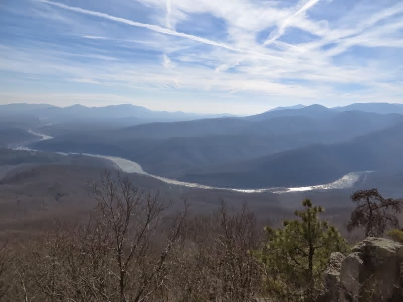
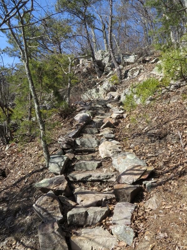
The trail led up to the base of cliffs (Fuller Rocks) and zig-zagged up stone steps to the ridge crest, also called Little Rocky Row. This is the scenic climax of the hike and I took a few minutes to soak it in. The James River laid a sinuous course far below with the sun reflecting brightly off the ice. To the northeast, the true summit, my big Numero 6-0, rose another 500 feet.
I continued the trek up the steepening ridge. Nearly to the top, I ceremoniously slowed for the final few steps. Two guys were there ahead of me and I had to boast, of course, of what I’d just accomplished. They congratulated me and seemed even a little impressed with the thin-haired guy humping up the trail with sticks.
One was kind enough to take my picture as I straddled two rocks that formed the highest terrafirma I could see. They agreed that the rocks under my boots contained the mountain’s most altitudinous molecules, whereupon we conjointly certified the completion of my quest. A 2,200-foot gain in 4.2 miles had officially sealed the deal.
It was kinda special stepping up on those last two rocks at Big Rocky Row—a great hike to end on. I’ll have to go back again with Kris in spring and linger longer.
The only downside of this particular trip to the mountain was that we had tickets to the Banff Mountain Film Festival at 6:00 pm that night at the National Geographic auditorium in DC. Which meant I nearly had to trot down the mountain and drive like a maniac to get back in time.
Happily, Kris held a seat for me, and I slunk into my chair a couple minutes into the first film. I had to smile when one of the later films tracked a guy who did 35 rock climbs to celebrate his 35th birthday. Now, how silly is that?
A Final Word
What a great feeling. To set a goal, in this case a reasonably achievable one, and then, well, achieve it. But all it was was me out doing what I like to do. Hiking. A lot. Seeing new places. Moving upward and looking back down. Meeting other trailsters. Manufacturing endorphins.
In the end, there were about 286 miles walked, 71,650 feet climbed, logged over a period of 252 days, or one summit every 4.2 days. When you average it all out, it ain’t that much—under five miles per summit and about 1,200 feet gained. So I’d have to put it somewhere between a sub-Olympian speedwalk and a drunken stroll around the neighborhood, probably more toward the latter.
Although I would have enjoyed more company on the trail, and it was great having Kris along when she could join me, the lonelier hikes were also very fun and scenic and appropriately self-indulging. And scintillating. Oxygenating. Life-enriching. I think I’ll do it some more. And hopefully again when I’m 70.
Happy hiking y’all.